Japan in Northwest Thailand during World War II
| N23°54.0± E97°39.5± |
Off Topic: Locating Loiwing airstrip(s), Yunnan, China Summary |
Route NA |
| Text | Notes | ||||||||
|
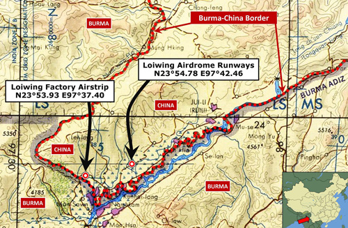
In Ruili, the westernmost part of Yunnan Province, China, two abandoned air facilities once carried the name "Loiwing" and were located within 8km (5mi) of each other:[i0]
This subject began with ick53993's asking 'Where was Loiwing?' on Dan Ford's Warbird's Forum message board back in 2007. By January 2008, the question remained unresolved and the thread went dead. Six years later, the thread reawakened. with new information Since that time, inevitably, information available as hardcopy and also on-line about the topic has increased. That included Google Earth's view of the area which in 2007-2008 had been severely hampered by low resolution imagery. Pages 1, 2, and 3 are intended to record how the rediscovery of Loiwing occurred. Page 1 presents information, generally available before US Air Force archival material was accessed late last year,[i1] which hints at the existence of two separate air facilities in the Loiwing area. Crucially, it does not do so with any clarity:
|
This section is currently best viewed with Google Chrome. See Key for interpreting page content. Revision list. See bottom of Text column on this page. Bibliography supports notes. Coordinates are from Google Earth, unless otherwise stated. Spelling of location names in English vary widely: Always a victim of transliteration skills, they may vary here, examples: Loiwing may also appear as Loi Wing; Manwing as Man Wing; and sometimes with hyphens And spelling will vary even more widely elsewhere; examples: Loiwing may be the same as Lei-yun, Lei‑yung, and Leiyong per l1nh4wk (31 Jan 2008 1037hr entry in Yuku Warbirds' Loiwing thread). And even wider variations can be seen, as in Loiwing Aerodrome, Loiwing (Suili), Ei‑Yun, Awlaw, Suili, Ruili, Juili, Shweli, Su-li, Ju-li, Namsham, Namshan, and Loping were all found to refer to the same airstrip, though the last, Loping, was later found to be in error. i0.^ Map extracted from TPC J‑10B, Burma China, Laos, Thailand, Vietnam (St Louis: Defense Mapping Agency Aerospace Center, Jul 1979). Map image extracted and enhanced with IrfanView; annotated with Microsoft Publisher by author. i1.^ I confess that I did not adequately access Gordon Seagrave's two books which were available for this initial effort --- I relied on quotes by contributors to the Warbird's Forum; hence most of the information I did get from his books appears in those pages following 1.
|